Birding Map and Guide for Forsyth County
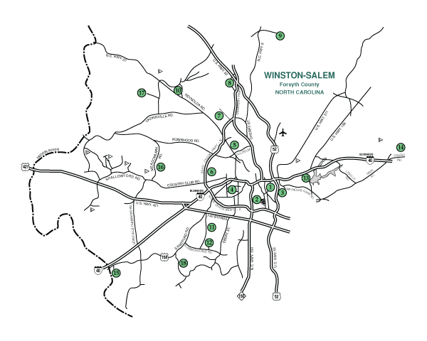
Winston-Salem, Forsyth County is a nice place to visit, and a growing number of people are living here. If you will drive a little and walk a bit, there are times and places for you to see most of the birds in the eastern United States. The purpose of this map and guide is to help you get to the places.
Directions start on either Business I-40 or Silas Creek Parkway. Silas is indicated as North or South of its intersection with Business I-40. The former termination of Silas Creek Parkway North at Reynolda Rd. is now Wake Forest Dr., and the parkway continues to become North Point Blvd. at Bethabara Rd. A street map will be helpful.
You also will want Forsyth Audubon’s FieldCheck List of Avian Species for Forsyth County. A hundred species have been recorded as nesting here, of which most are common, and over 290 species total. Migration is in April-May and September-October. Our Christmas Count tallies 70-90, the Spring Count is 120-150.
For more detail on Birding Spots in Forsyth County, click on any of the links listed below.
For a complete list of 85 parks and greenways visit:
www.forsyth.cc/parks
www.cityofws.org/departments/recreation-parks/parks-greenways
Thanks to Forsyth Audubon’s EDIB Committee and Forsyth Audubon volunteers, accessibility information for many of our local parks can be found on Birdability.org. Visit that site, and click on the Birdability map, and use the Zoom in key to find the parks in our area with accessibility information. Or type the park you want in the search bar.
Click here to download a printable version of this map.
| 1. Old Salem | 10. Bethania |
| 2. Washington Park | 11. Archie Elledge STP |
| 3. Civitan Park | 12. Hobby Park |
| 4. Miller Park | 13. Salem Lake |
| 5. Reynolda Gardens | 14. Triad Park |
| 6. Shaffner Park | 15. Tanglewood Park |
| 7. Historic Bethabara Park | 16. Muddy Creek Greenway |
| 8. Kaleideum (SciWorks) | 17. C.G. Hill Park |
| 9. Horizons Park | 18. Lower Muddy Creek STP (and surrounding area) |
| Other Nearby Birding Spots |